by Barbaree | Jan 19, 2012 | Free Resources, Our Blog
With ClimateWizard you can view historic temperature and rainfall maps for anywhere in the world. View state-of-the-art future predictions of temperature and rainfall around the world. View and download climate change maps in a few easy steps. ClimateWizard enables...
by Barbaree | Jan 18, 2012 | Free Resources, Our Blog
Stress on water resources poses a threat to sustained business growth. It also creates an opportunity for competitive advantage through effective water risk management. In the past, no tools existed for companies, investors, and others to track water risks at a scale...
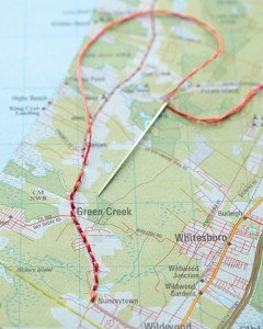
by Barbaree | Jan 16, 2012 | Cougar's Corner, crafts, Our Blog
Looking for a clever way to display a favorite or locally focused map? Try this – use different sizes of embroidery hoops to \”frame\” your maps. Trim off the excess after they are set the way you like, then simply hang on the wall! You can also...
by Barbaree | Jan 13, 2012 | Apps We Love, Free Resources, Our Blog
This is the ultimate in FREE earthquake apps! Quake Feed features six different basemaps provided by ESRI and an information feed of the past 7 days of earthquakes with magnitude > 2.5, displayed in a map or list format. Includes a variety of user-friendly filter...
by Barbaree | Jan 12, 2012 | Free Resources, Our Blog
The BOOST portal features data rich maps of Kenya. Highly specialized and perfect for an AP Geography class to explore. Use the drop down menus and expolre (by year and by sector): poverty rates, household data, education statistics, employment rates, power...
by Barbaree | Jan 11, 2012 | Free Resources, Our Blog
Explore a rich variety of fossil data with maps and trace the ecosystem as it collapses and rises over time with Walkabout through Time from the Carnegie Institute for Science. When people first came to Australia, about 55-60,000 years ago, the landscape was very...
