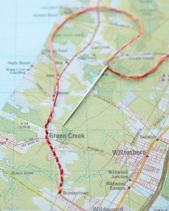
by Barbaree | Jan 16, 2012 | Cougar's Corner, crafts, Our Blog
Looking for a clever way to display a favorite or locally focused map? Try this – use different sizes of embroidery hoops to \”frame\” your maps. Trim off the excess after they are set the way you like, then simply hang on the wall! You can also...
by Barbaree | Jan 13, 2012 | Apps We Love, Free Resources, Our Blog
This is the ultimate in FREE earthquake apps! Quake Feed features six different basemaps provided by ESRI and an information feed of the past 7 days of earthquakes with magnitude > 2.5, displayed in a map or list format. Includes a variety of user-friendly filter...
by Barbaree | Jan 12, 2012 | Free Resources, Our Blog
The BOOST portal features data rich maps of Kenya. Highly specialized and perfect for an AP Geography class to explore. Use the drop down menus and expolre (by year and by sector): poverty rates, household data, education statistics, employment rates, power...
by Barbaree | Jan 11, 2012 | Free Resources, Our Blog
Explore a rich variety of fossil data with maps and trace the ecosystem as it collapses and rises over time with Walkabout through Time from the Carnegie Institute for Science. When people first came to Australia, about 55-60,000 years ago, the landscape was very...
by Barbaree | Jan 10, 2012 | GIS Happenings, Our Blog
Torrential rain inundated southeastern Brazil in early January 2012, causing severe damage in multiple states. The floods forced thousands from their homes, damaged roads and homes, and broke through a levee in northern Rio de Janeiro State, according to news reports....
